About Sierra Valley Preserve
It takes a community to protect this important place. The Sierra Valley Preserve is a unique landscape with abundant wildlife, plants, and cultural resources—some of which are rare and fragile.
Conditions Update: Both West and East entrances will be closed for these upcoming dates: Wed. 1/17, Wed. 1/24, Wed. 1/31, and Sat. 2/3
West Entrance Hours: Open year-round from sunrise to sunset.
East Entrance Hours: Open year-round from sunrise to sunset.
Parking: West Entrance: Please park in the designated parking area. East Entrance: Please park in the turn-out/parking area. Foot traffic only beyond the gate.
Camping: Camping and overnight parking is prohibited.
Accessibility: The West Entrance has ADA compliant parking and accessible sections of trail with beautiful views of the wetlands and wildlife habitat. If you have a disability and would like a gate code for ADA access to the parking and trail beyond the West Entrance primary parking lot, call (530) 283-1793. Have general questions about accessibility and terrain? Call (530) 283-9095 to speak with Kevin Stammerjohn, Preserve Manager.
Motorized Vehicles: No motorized vehicles beyond the parking areas.
Pets: Dogs are not permitted at the Sierra Valley Preserve due to sensitive wildlife and livestock.
Trails: Please keep foot traffic to paths and trails. Bikes are not permitted beyond the parking areas.
Restrooms: There are seasonal port-o-potties at both West and East Entrances.
Trash: Please pack out your trash. No trash receptacles on-site.
Smoking: Smoking is prohibited.
Fires: Fires are prohibited.
Events: Permits are required for all organized group events. Please email info@frlt.org with your full name, contact info, and a short description of your group/event and our team will get back to you. (No weddings or other large private events at this time.)
The preserve’s 2,575 acres have a rich variety of habitats including montane meadows, dynamic wetland channels, and upland areas of sagebrush scrub, ancient dunes and spring wildflowers.
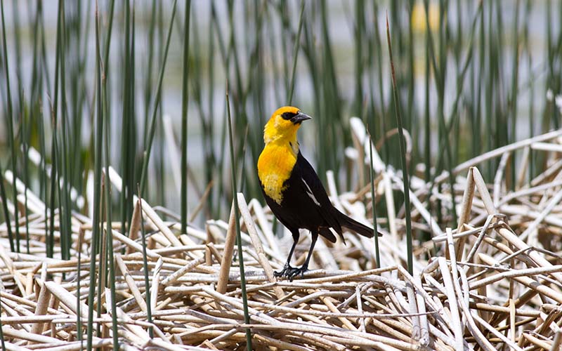
The Preserve is a key stopover on the Pacific Flyway. Its seasonal and perennial wetlands provide migratory and breeding habitat for sensitive species such as Greater Sandhill Cranes, Black Tern, Redhead, White-faced Ibis, and 200+ pairs of Yellow-headed Blackbirds.
3 miles of family-friendly interpretive trails meander through the Preserve, offering amazing 360-degree views of mountains near and far.
- West Entrance: Follow the botanical trail to the historic Bulson House and along the bluff to take in wetland and meadow vistas.
- East Entrance: Walk a short interpretive trail through to the wetland-edge bird viewing platform and picnic spot.
Coming soon: More trails and a new Preserve headquarters and nature center.
Directions
The Preserve offers year-round public access from two different entry points. The West Entrance has ADA compliant parking, a botanical trail, and views of the Bulson House and other interesting features. The East Entrance, also know as the Maddalena Property, has a level, but rustic interpretive trail, access to the wetlands and water’s edge (on wet years), and an elevated birding platform.
West Entrance directions from Highway 70
Drive south on County Road A23 (Beckwourth-Calpine Road) for 2.7 miles. Look for a large gate and sign on your left (entrance). Enter and park in the designated parking area. A kiosk features a property overview map and highlights. There is a seasonal port-o-pottie.
East Entrance directions from Highway 70 Beckwourth, CA
Drive south on County Road A24 for 1.75 miles to the wooden corrals on your right. Park in the turn-out/parking area (foot traffic only beyond the gate). The trail to the bird watching platform starts in the corrals. There is a seasonal port-o-pottie.
Preserve Overview Map
Download a map of the preserve to use while visiting the property.
FRLT’s Sierra Valley Preserve offers year-round public access in Sierra Valley for walking, botanizing, nature photography, birding, seasonal boating, and naturalist-led events. The Preserve offers a wildlife viewing platform, interpretive trails, and picnic areas. Now, we’re working with our partners to create more trails and a new Preserve headquarters and nature center for learning, recreation, and stewardship (opening in 2024).
Birding
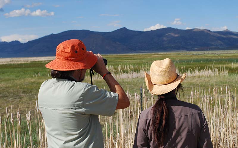
If you are a birder, or even just bird-curious, the Sierra Valley Preserve is the place to be! In spring and summer look for songbirds and large numbers of waders and shorebirds. In fall and winter expect to see a high density of raptors. In late winter and early spring migrating waterfowl are common too. The East Entrance of the Preserve, also known as Maddalena Property, has a birding platform with interpretive signs to help you identify birds you may see, and is an eBird hotspot.
- Spring/Summer
- American Avocet
- White-faced Ibis
- Black-necked Stilt
- Yellow-headed Blackbird
- Sage Thrasher
- Brewers Sparrow
- Greater Sandhill Crane
- Osprey
- Fall/Winter
- Rough-legged Hawk
- Northern Harrier
- Ferruginous Hawk
- Golden Eagle
- Bald Eagle
- Short-eared Owl
Get the Sierra Valley Birder’s Guidebook for a species checklist and a map to good birding hotspots.
Walking
The Preserve currently features nearly 3 miles of interpretive trails.
From the West Entrance, explore wildflowers and native plants along the Rebecca Wenk Botanical Trail. Look out over the wetlands and take in big valley views along the ADA Bluff Trail. Both trails lead to the Jenner Mountain Overlook.
The East Entrance has a 3/4 mile trail leading to the bird viewing platform that is a great introduction to Sierra Valley and a casual, easy walk for most people.
The Preserve is a great place to stretch your legs and take in 360 degree views en route to other destinations, too.
Wildflowers
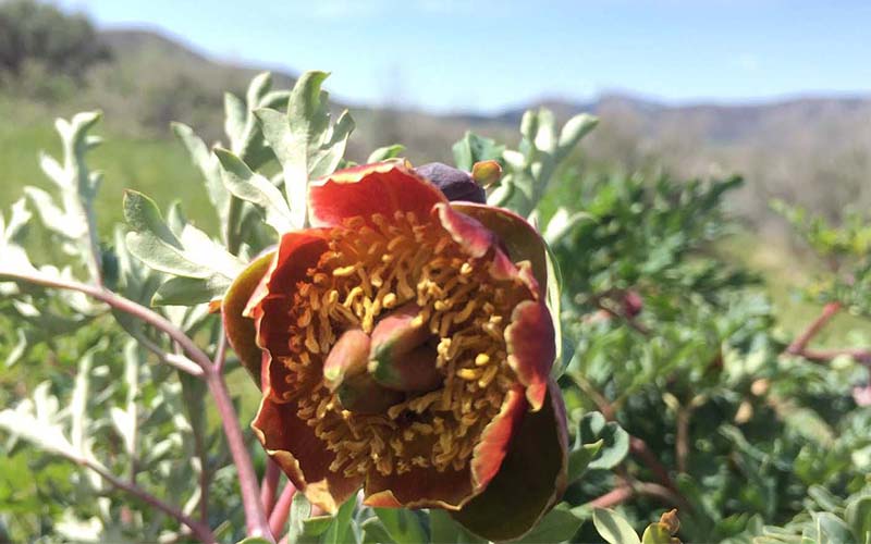
Located at the convergence of three geographical regions, Sierra Valley is botanically biodiverse. The interesting terrain may at first glance look like a lot of sage brush but take a closer look in the months of April through June to see flowering bitterbrush, camas, Brown’s peony, sand lilies, Sierra Valley evening primrose, meadow penstemon, irises and more.
Photography
Sierra Valley is so interesting! Is it the high desert? Is it a wetland savanna? Are those shorebirds? The Preserve is a great place to get out for big views, unique perspectives, and a landscape like no other. Early mornings and evenings can be chilly but often showcase colorful skies, mist rolling off the water, awesome cloud formations, and mountain silhouettes. Bring a zoom lens for wildlife photography and a macro lens for up-close flower and insect shots. We’d love to see what you capture! Share your photos: #SierraValleyPreserve
Road biking
Sierra Valley is a big, mostly flat valley with epic views and country roads. Park at the Sierra Valley Preserve East Entrance and head out on a road bike adventure through and around the valley. Be aware that the paved roads of Sierra Valley have little to no shoulder and are frequented by trucks, trailers, and farming equipment. While beautiful, Sierra Valley can be extremely windy and can range from very cold to very hot (sometimes within hours). Always check conditions and be self-supported and prepared for the elements. There are a couple of groups that organize rides annually—take a look online.
Kayaking/Canoeing
Boating the wetland channels of the Middle Fork Feather River is an amazing experience but also a complicated one. Because the wetlands are tremendous habitat for birds and other wildlife, being in the water may impact and disturb breeding and nesting season. For this reason, boating from the Sierra Valley Preserve is regulated seasonally. Please check our boating guidelines before planning a trip.
Located at the convergence of the Great Basin, Sierra Nevada, and Cascades, Sierra Valley is a giant mountain basin that was once an ancient Pleistocene lake. Because of its unique geography, vast water resources, and natural abundance, Sierra Valley has long been a gathering place of people and cultures. The first known inhabitants of Sierra Valley are the Washoe and Mountain Maidu, who continue to enjoy the beauty and resources of the valley today.
In 1850, African American mountain man Jim Beckwourth encountered Sierra Valley while using tribal trails to scout a new wagon train route across the Sierra Nevada. The historic Jim Beckwourth trail passes through the northern portion of the Preserve. Similar to other working ranches in Sierra Valley, the Preserve has been farmed and ranched since the late 1800s, and portions of the Preserve continue to be sustainably grazed by a local ranching family.
The Feather River Land Trust acquired the 2,575-acre Preserve over more than a decade, working with local landowners and our conservation partners, The Nature Conservancy and the Northern Sierra Partnership.
Photo by Katie Bagby/FRLT Staff
Photo by Andrew Wright/Lighthawkphoto
Photo by Vanessa Vasquez
Preserve Activities
![]() Birding
Birding
![]() Cross Country Skiing
Cross Country Skiing
![]() Interpretive Trail
Interpretive Trail
![]() Photography
Photography
![]() Picnicking
Picnicking
![]() Road Biking
Road Biking
![]() Walking
Walking
![]() Wildflowers
Wildflowers
Get the latest
Sign up for updates and event invitations